These contents are for when you are staying within a city or perhaps going to a neighboring city. For longer distances and much higher speed buses, you’ll want to see the contents on intercity and express buses which go on highways, have only one or a few stops, and will need to purchase separate tickets prior to departure.
While English can use the terms bus stop and bus shelter (정류장, 停留場, jeongnyujang), the term bus stop is more common. The bus stop itself is the only place you will be able to board a bus. It doesn’t matter if you are along the route and see the bus between stops as it will not stop for you. Safety and travel time are bigger priorities than picking up as many passengers as possible. Don’t try to flag down a bus that is not at a stop as it will completely ignore you.
When you want to ride a bus, stand up near the street edge and make eye contact with the bus driver. It isn’t necessary to use your hand to signal the driver. If your body language suggests to the driver that you want to ride the bus, then the bus will stop so you can get on. Depending on the city and the bus operator, buses might be required to fully stop at all stops and might be required to open and close the front door, even if there aren’t waiting passengers.
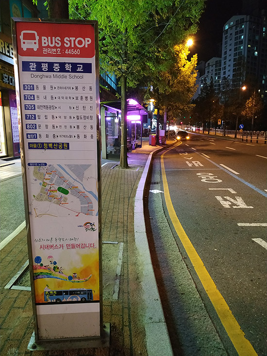
This first image is a good establishing image to show most of the items you’ll see at a bus stop. We first see a freestanding sign declaring it to be a bus stop, we see the stop behind it, we see paint on the ground to tell drivers now to park here, and the road is indented so buses can stop and not impede traffic which depends on the urban planners for that area.
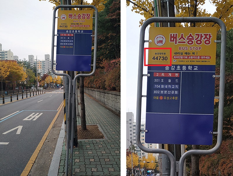
Here is another pole declaring this to be a bus stop. The name of the stop is written, only in Korean this time but was bilingual on the previous image, and all buses that stop here are listed. Also note the red square drawn on the right image. Inside the box are the words 승강장번호 (乘降場番號, seunggangjang beonho) and the number 44730. The words mean “platform” and this is to indicate the exact bus stop. Bus stop names don’t typically change, so that isn’t the issue here. However, there are bus stops on both sides of this street – and they have the same name. So how is someone to know which side to the street they should go to board the bus? This is where the number is critical. This number tells you the side of the street you should be on to get your bus.
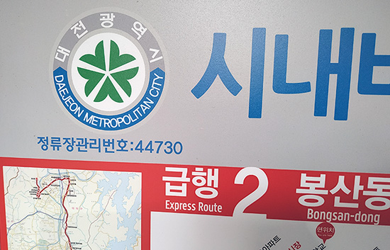
This unique number can be found in other locations as well. Here it is written on the corner of a bus route map attached to the rear wall of the bus stop. We can see this same 44730 number is here. In this instance the words are different (정류장관리번호, 停留場管理番號, jeongnyujang gwalli beonho) and can be translated as “bus stop administrative number”. Regardless of the wording, the number system is consistent.
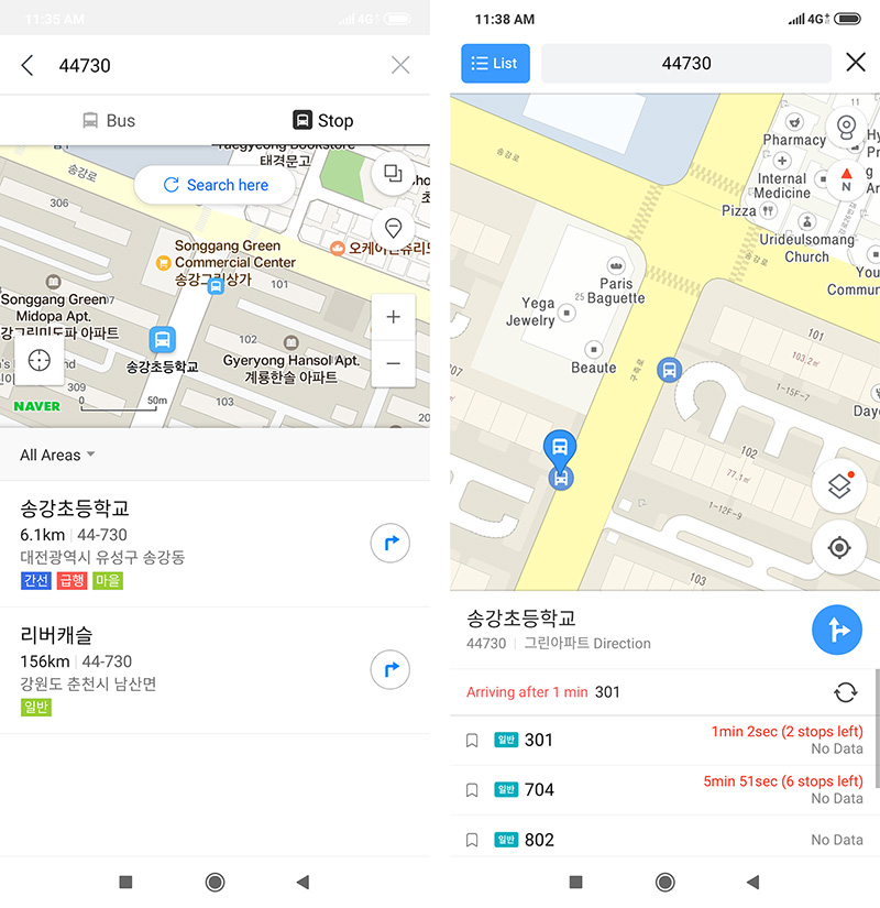
If you have a mapping app on your phone, open it up and search for the 44730 number that we saw. Here are screenshots from Naver Maps (left) and Kakao maps (right) showing the location we are at, what buses come here, and the location of the area which helps us to confirm we are at the correction location.
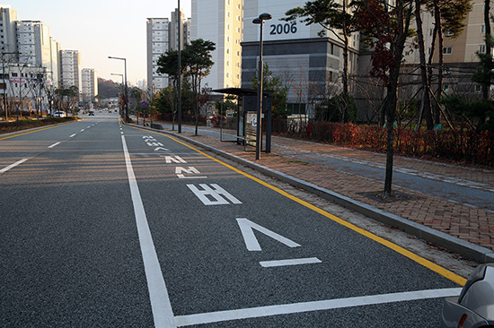
Here is a bus stop that is to the right of the road, which is the vast majority, the road is widened so the buses can stop and not impede traffic, and we see some words written on the ground; 지선버스 (支線버스, jiseon beoseu) which translates as “route buses” meaning no express or intercity buses and usually no airport buses. If you want to see the image and words more clearly, click the picture to see a larger version.
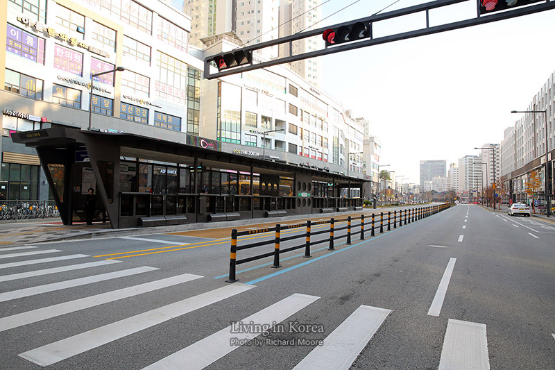
Not as common except for parts of Gyeonggi Province, Sejong City, and some other locations, are BRT or Bus Rapid Transit. Modeled off of Bogota’s BRT system (citation) these buses are in a semi closed system where only buses are allowed and the bus stops are in the middle of the road. Also shown is the buses have their own signals as well. Click the picture to see a larger version.
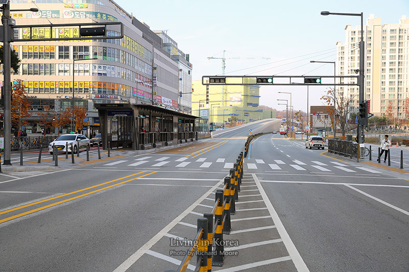
Here is the same area but facing the opposite direction. We can see that the bus stops are not quite across from each other as they are offset somewhat. We can also see a special bridge that is exclusive for these BRT buses. It is worth noting that just because there are BRT bus stops installed, it does not mean all buses stop there. That was initially tried in some parts of the Seoul Capital Area in the early days of the Korean BRT, but it was found that the sheer number of buses squeezing into a one lane road without the possibility to easily pass each other, created massive bottlenecks and actually slowed the system down. It was revised so certain buses travel in these 24/7 exclusive and blocked off bus lanes, which other buses stay in lanes shared with other vehicular traffic. Click the picture to see a larger version.
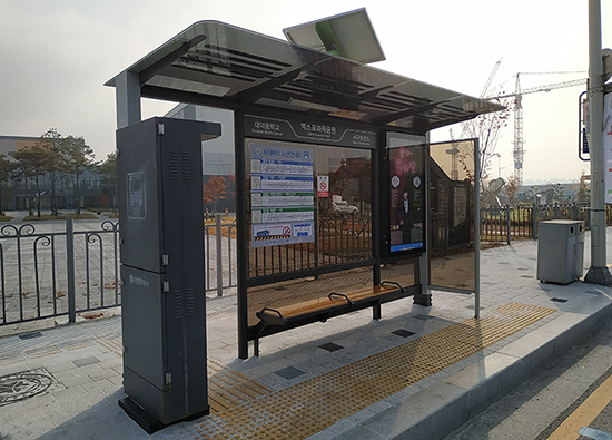
Now let’s look at what a bus stop itself looks like. And while we’d love to show you the one and only design that exists, that just isn’t possible as there is a large variety of designs and concepts for what a bus stop looks like. Here are three examples, all from the same city. This first image is near both the National Science Museum (website, Wikipedia) and the Institute for Basic Science.
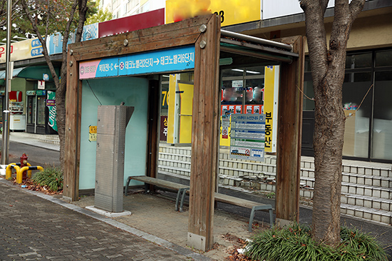
This next stop is northern Daejeon, close to Techno Valley in the middle of a residential area. It is roughly a 15-minute ride away from the first example.
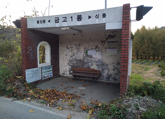
This last example is a very old countryside style bus stop and is located another fifteen minutes north of the second example. Another ten minutes from here and you’ll reach the RAON particle accelerator (website, Wikipedia).
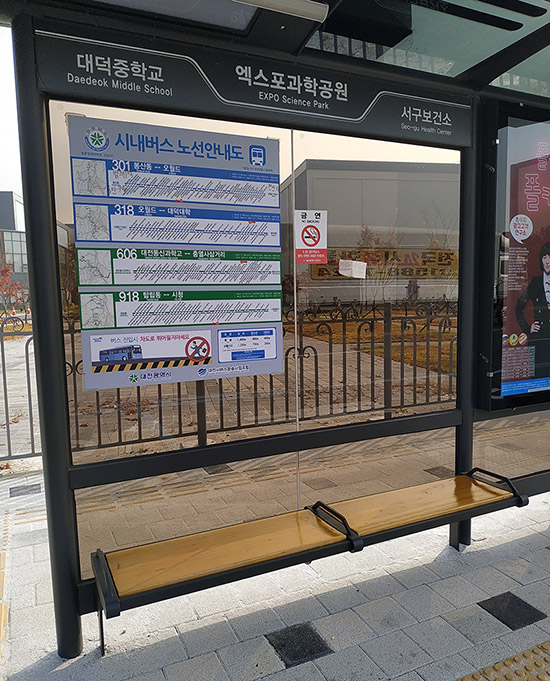
Looking at all of these examples, we can see they all have a bench and have a route map on the rear wall. If a bus stops here, the bus number and their full route will be written. Do note that a bus stopping on one side of the street may not stop on the other side of the street. More on that in a minute. Bus stops and buses are non-smoking.
Somewhere near the top is the name of the stop, hopefully bilingual, the next stop on this street and the previous stop. Take the next and previous stop information with a grain of salt as buses can turn and go a different direction.
Bus routes rarely change, this includes their stops, the departure time of the first bus, departure time of the last bus, and the intervals. But sometimes this information changes. When it does change, the route map(s) get updated and the date is posted. If in doubt, check the date and see if it is anything recent. In the top right corner of this image we can see these route maps were last updated 29 September 2017.
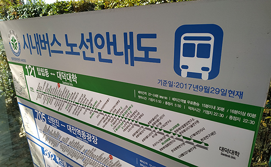
One thing you’ll quickly notice is the lack of any language other than Korean. While this will presumably change in the future, the bus system is largely monolingual. Look at the stops on the very left. The first four line up with them appearing on the top and bottom. However, the fifth stop is different and even if you can’t read Korean you can see the first four stops have an oval chunk missing on the line but the fifth stop on the top and bottom both have a half oval. While most buses will visit both sides of the street for their route, this isn’t always the case and is something to keep in mind.
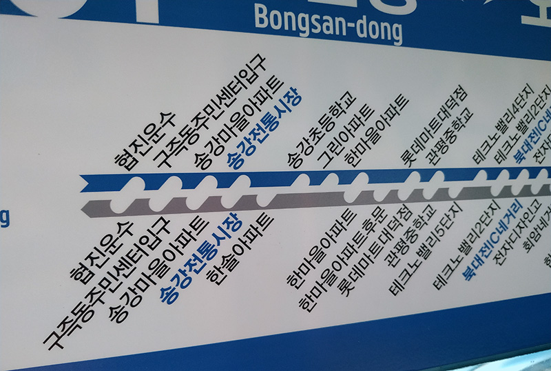
If you have a keen eye you might have noticed the previous image and following image are nearly identical. The key difference is a small sticker indicating where you currently are. For many years there was no indication, even in Korean, to potential passengers as to their current location on the routes. This meant that even if your Korean was good and you had lived in a city for years, it could take awhile to find where you are on a route map, see where the bus goes, and then determine if that bus was one you wanted to ride or not.
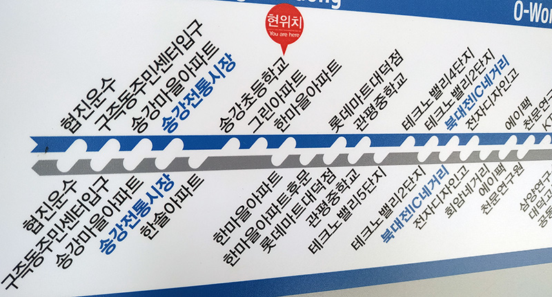
Currently, many bus stops have some indication to show where you are which allows you to scan the routes much faster. If you have trouble reading Korean, if you are unsure which direction is north, or if you are just new to an area; it could be easy to get lost and head the wrong direction on a bus. However, there are sometimes other indications that show which direction the bus is going. This next image has a "you are here" style image and an arrow, which makes it very easy to see. But look again at the left side of the previous two images. Note the end of the line isn't flat but instead > on the first line which can be seen as an arrow -> and now see the < on the second line which acts like an arrow pointing the opposite direction <-.
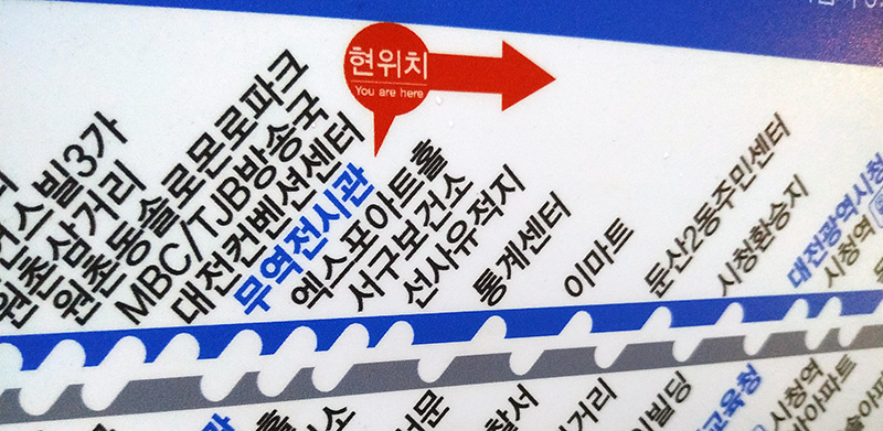
Off to the side of the route map will be information pertaining to the first bus, the last bus, and the average interval. The following images will show the information in more detail and translate enough so you can get a good idea of what is presented. If you want to see this timetable more clearly, click the picture to see a larger version of that section of the image. Also note that on this route map each stop is either a train, meaning a subway or train connection, or has an arrow to show the direction the bus is traveling.
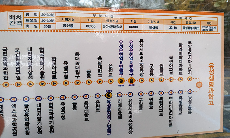
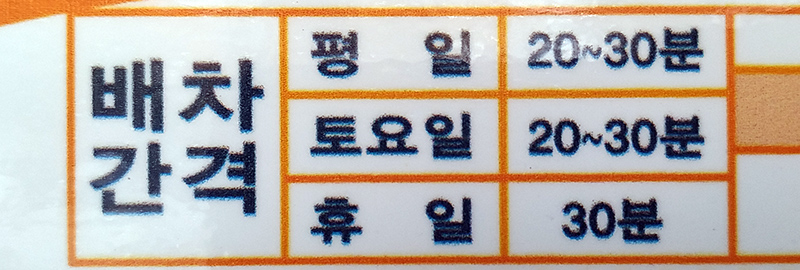
Going from left to right, this first image shows the interval is dispatched buses (배차간격, 配車間隔, baecha gangyeok). The first category is for weekdays (평일, 平日, pyeongil) and soa bus comes every 20~30 minutes (분, 分, bun). The next shows Saturdays (토요일, 土曜日, toyoil) with the same 20~30 minutes, and then holidays (휴일, 休日, hyuil) with a bus every 30 minutes.
Next it shows what time the first bus departs the depot (첫차시간, 첫車時間, cheotcha sigan) and this is the same term used for the departure of the first subway car at the first station. Keep in mind, this is when the first bus leave the depot, not when the first bus is here. If you are close to the starting location, the bus will come quickly. If not, you’ll need to wait longer. Next line says the name of the first stop (기점지명, 起點地名, gijeom jimyeong). Next we see 시간 (時間, sigan) which means time. In this case the name of the first stop is 보상동 and it leaves at 6 AM.
Looking to the right side, we see the word 종점지명 (終點地名, jongjeom jimyeong) which means the last stop. In this case the name of the last stop is 유성생명과학고 and buses will depart from it at 6 AM.

The last section is nearly identical to the last section, except this displays when the last bus departs from the depot (막차시간, 첫車時間, makchasigan). The rest of the terms are the same except we see a few more words at the bottom right. These are the same words we saw in the first box; 평일 for weekdays, 토 which is the abbreviated version of 토요일 (Saturday), and 휴일 for holidays.

Sometimes you will see a bus running after the system was supposed to be finished. You might get excited and try to catch this bus. The problem is the bus you see might not officially be running the route. For busses that are not picking up passengers nor stopping at bus stops, they will display 운행종료 (運行終了, unhaengjongnyo) in large red letters at the front LED display above the windshield. This lets people know they cannot get on this bus. This could appear for several reasons, including a vehicle was having issues and is returning to the terminal to get serviced, meaning you might see this during daylight hours as well.
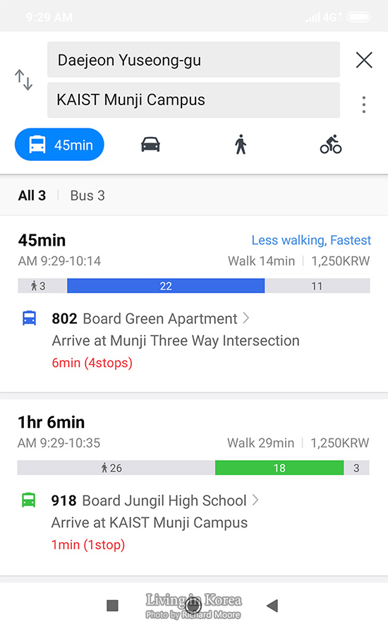
Now we know which buses come, what stops they visit, and how often they will come. The last bit of information is what bus is coming next and how long we need to wait until our bus comes. If we are using a smartphone app, we can see how long until the buses come. In the below screen capture, we see that bus 405 is 4 stops away, which is roughly 6 minutes until it arrives here. Meanwhile bus 918 is 1 stop away and will arrive in 1 minute.
This information is also available at a number of bus stops, but not every bus stop. The city, the line, and the location all determine if there is a freestanding machine dedicated to telling the same information. Here are two examples from the same city; again that city is Daejeon. Alternative versions could be a hanging LED sign connected to the ceiling of the bus stop; shown a few images down this page. If you want to see the image more clearly, click the picture to see a larger version.
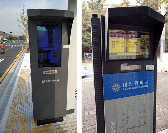
The format, words, and other details are variable for different cities, so don’t expect this same user interface to be the same for every city, or even in a different area of the same city. In this occasion we see the 301 bus is about to arrive (진입, 進入, jinip) and it is currently pulling up now (정류장 진입, 停留場 進入, jeongnyujang jinip). Bus 606 is at the 샘머리아파트 bus stop, which is four stops away. Meanwhile, bus 318 is so far away they are not displaying how many stops away it is.
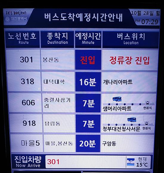
At the bottom of this guide it tells us the bus or buses that are about to arrive. If you bus is coming, stand up and work your way over toward where the bus will pull in. If it looks like you aren’t going to ride the bus, the driver will do a rolling stop and will leave without you.
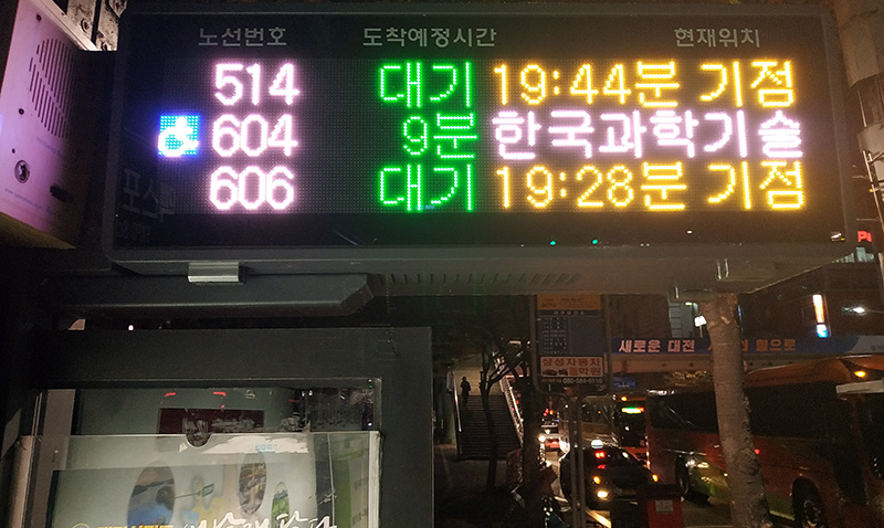
Some bus stops have freestanding machines dedicated to telling incoming bus information. Other bus stops might have a hanging LED sign which shows a few buses at a time. Some bus stops have both sets of signage but don’t expect these at quieter stops.
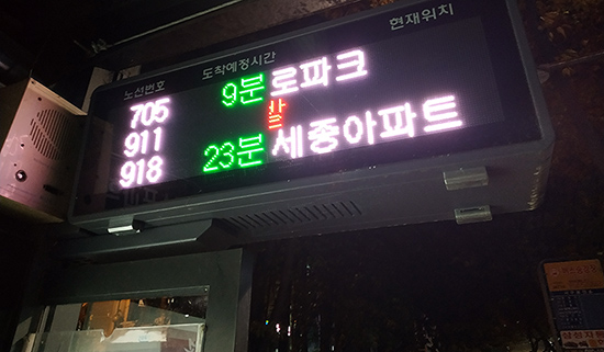
Here is the same display showing different bus information. On the left side we see the icon for a wheelchair. This comes up for low-floor buses and there is a foldable seat designed for a wheelchair to occupy. Some of these buses have special buttons that the individual will press so the driver knows to give more time for the person to exit the bus.
